- INSTALL SMB NAVIGATOR ON YOUR ROKU
- CONFIGURE A NMEA2000 GATEWAY
- SUBSCRIPTION PLANS
- APP CUSTOMIZATION
- MAPS
- REMOTE ACCESS
- HOW TO USE
- TILE VIEW AND DOWNLOAD

How to install SMB Navigator on your Roku
Just like you access an “app store” on your smartphone to add new applications, you access the Roku Store to add new channels or apps to your Roku streaming device or Roku TV.
Browse for SMB Navigator in the Store on your Roku streaming device, on channelstore.roku.com, or on the Roku mobile app. If you’ve set up a Roku account PIN, you’ll be required to enter it to add the app and sign up for a subscription.
Note that when you add SmartMyBoat Navigator to your Roku device, you’re actually adding it to your Roku account. As a result, the app will automatically be added to all Roku devices linked to your Roku account. When you remove the app, the same is true — it will be removed from all Roku devices linked to your Roku account.
Adding SMB Navigator from your Roku device
- Press Home home button on Roku remote on your Roku remote
- Scroll and select Store
- Select Channels, then search for “Navigator”
- When you want to learn more about an app, press OK on your remote
- The app requires a subscription, select OK to start a free trial or purchase a subscription
The app will be added to the bottom of the list of apps on the home screen. If you prefer, the app can be moved higher up the list.
Adding Navigator from Roku.com
-
- Adding Navigator from the Roku mobile app
- Go to channelstore.roku.com
Install
- Sign in to your Roku account
- Search for “Navigator”
- Select Add channel to install the app on your Roku device
If the app does not appear on your Roku device, go to your Roku device and select Settings > System > System update > Check now.
Adding Navigator from the Roku mobile app
- On the Roku mobile app, browse the categories and genres, search to find a specific app, or go to the Store
- Select an app to view more information
- Select Add channel and follow the instructions to install the app on your Roku device
If the app does not appear on your Roku device, go to your Roku device and select Settings > System > System update > Check now.
How to install Configure a NMEA2000 gateway
The NMEA 2000 Wi-Fi Gateway allows you to see data from a NMEA 2000 marine digital network on a PC, smartphone or Roku. With it, you get marine network data including vessel course, speed, position, wind speed and direction, water depth and other navigation data in popular software applications.
The gateway creates its own Wi-Fi network (with range of about 100ft in open spaces) or it can be connected to an existing Wi-Fi network. In the second case, the coverage depends on coverage of the base network. In either case this is the network to which you will connect your Roku device.
To configure the gateway, you need any Wi-Fi enabled device with any web browser. Gateway settings can be reset to the factory values using the hidden reset button.
Most gateways automatically records your track with weather, depth and other data to the internal memory. These data can be saved from the internal web site to GPX (for Garmin MapSource, Google Earth or other cartographic applications) or CSV (spreadsheet) files.
If the Gateway has an internet connection, it can automatically upload recorded data to Cloud Service. Cloud Service allows easy access to your tracks or monitor your boat from home and lets you share your position with family and friends.
| Brand/Model | Key Features | Navigator for Roku | Link | |
| Actisense W2K-1/W2K-2 | NMEA 2000 to Wi-Fi, built-in data logger, supports NMEA 0183 conversion | Supported | Tested | NMEA 0183/NMEA 2000 |
| Actisense WGX-1 | Wi-Fi and Ethernet, versatile connectivity, supports multiple data formats | Supported | Tested | NMEA 0183/NMEA 2000 |
| Actisense NGX-1 | Bi-directional NMEA 0183/NMEA 2000 converter, USB/PC interface | Supported | Not Tested | NMEA 0183/NMEA 2000 |
| Yacht Devices YDWG-02 | NMEA 2000 to Wi-Fi, web-based gauges, supports RAW protocol | Supported | Tested | NMEA 0183/NMEA 2000 |
| ShipModul Miniplex-3Wi-N2K | Wi-Fi, NMEA 2000, supports multiple connections | Contact us for help | Not Tested | Likely supported |
| Hat Labs SH-wg | NMEA 2000 to Wi-Fi, supports Signal K, multiple data formats | Contact us for help | Not Tested | Likely supported |
| Digital Yacht WLN10 Smart | This smart NMEA to WiFi gateway allows tablets & mobile devices to connect to existing on board GPS, AIS and instrument systems.” | Contact us for help | Not Tested | Likely supported |
| Quark-Elec QK-A032 | Bi-directional NMEA 0183/NMEA 2000, USB, Wi-Fi, AIS support | Contact us for help | Not Tested | Likely supported |
| Maretron IPG100 | Internet protocol gateway | Contact us for help | Not Tested | Likely supported |
| Comar i320W | Bi-directional NMEA to Wi-Fi, supports multiple protocols | Contact us for help | Not Tested | Likely supported |
| Rose Point Nemo Gateway | NMEA 0183/NMEA 2000 converter, USB/PC interface | Contact us for help | Not Tested | Likely supported |
| Device not listed? | Install SMB Navigator and submit feedback |
Connect SMR Navigator to the gateway from Settings – press * on your remote while Navigator is opened.
- Settings > Device > Device type to select Actisense or Yacht Devices.
- Settings > Device > IP address to enter the address of the gateway.
- Settings > Device > Port to enter the port on which the gateway is transmitting.
Adding Navigator from the Roku mobile app
Subscription Plans
Navigator has monthly and annual subscriptions including free Trial for a new user. There are different ways to manage or cancel subscriptions.
SMB Navigator subscriptions are done exclusively through Roku. Go to my.roku.com/subscriptions to manage or cancel your subscription. You can also do this on your Roku device, but not through the Roku mobile app. See the following steps for more detailed instructions.
Note: Subscriptions auto-renew unless canceled. You can use the service until the end of the billing period after canceling.
Manage or cancel a subscription through Roku
To check whether the subscription is being billed and managed through Roku, go to my.roku.com/subscriptions. It will be listed here. You can also check your billing statement: Subscriptions billed by Roku will show up on as a charge from “Roku,”, “The Roku Channel”. It will most definitely contain word “Roku” someplace on the statement.
Manage Subscriptions using Roku website
Customization
- Go to my.roku.com/subscriptions
- Under Active subscriptions, select the subscription you want to cancel. These are only subscriptions through Roku.
- Select Manage Navigator subscription and then select Turn off auto-renew. Turning off auto-renew means you’ve canceled your Navigator subscription and you will not be billed for it in the future.
- After canceling your subscription, you’ll continue to have access to Navigator until the end of your current billing cycle.
Manage Subscriptions on your Roku device
- Press the Home home button on Roku remote button on your Roku remote.
- From the Home screen, use the arrow buttons on your remote to hover over and highlight the app whose subscription you want to cancel.
- Press the Star star button on Roku remote button on your remote.
- Select Manage subscription to view the renewal date and access additional options. If you don’t see this option, your subscription is not managed through Roku.
- To cancel a subscription, select Turn off auto-renew. Your subscription will now only be active until the end of its billing cycle.
Deadline for canceling a subscription
Subscriptions auto-renew unless otherwise noted. You can cancel a subscription anytime. If you cancel with time left in your billing period, you can use your subscription until the end of the billing period. No partial-term refunds are provided. Free trials must be canceled before the free trial period ends to avoid recurring subscription charges.
What to do if you’re still being charged after canceling your subscription
If you’re still getting charged after you’ve canceled a subscription through Roku and the billing cycle has ended, follow instructions on identifying charges you do not recognize. If after doing so, you’re still having issues with a Roku subscription, contact Roku customer support. SmartMyBoat does not process, manage or is able to cancel any payments, declines, refunds or has any capability to access any subscription related user information.
Customize your SMB Navigator Screen
User is currently able to control:
- Options (*) > View > Navigation Screen – Which instruments/gauges will show on the Navigation screen. Use a checkbox to Show or hide each.
- Options (*) > View > Misc Screen > Tanks – On the misc screen user can bind each or the tanks a specific tank instance present physically on the vessel. (Assuming each is connected to NMEA2000 network.
- Options (*) > View > Misc Screen > Batteries – Show or hide all batteries currently installed on the vessel .
- Options (*) > View > Misc Screen > Propulsion – Although under a test user can display up to two engine related data in a form of RPM/Temperature gauge for each engine separately.
- Options (*) > Device > Type > Actisense/Yacht Devices – These gateways has been tested during development.
- Options (*) > Device > IP address – Enter IP address of your NMEA gateway.
- Options (*) > Device > Port – Enter PORT number you configured during NMEA gateway setup process
Press Reload button on your remote to refresh data from NMEA network.
Use Left/Right button on your remote to control which screen is displayed.
We are continuously working on adding more relevant instruments.
Maps
Starting from SMB Navigator for Roku version 1.3 we are supporting maps. Open Street Maps and Open Sea Map overlay is added. Due to limitations of Roku platform the app file size must be 4 MB or less which is not nearly enough to store maps and since only some Roku® streaming devices include a USB port to which you can connect an external USB drive maps must be downloaded before being used. Fortunately process of downloading maps is easy and can be done even with slower internet connection.
- Use Up/Down while on Maps screen to zoom in/out
Downloading Maps
Open maps screen by keep pressing right button on your remote until maps screen is shown.
- While on the screen press Play button to open Download Maps dialog
- Left-Right to Select Min and Max zoom level
- Up – Down to change selected option
- Select Start and Ok to start Downloading – If the download is running OK to cancel download
- Back to close the dialog
- App will estimate how many tiles to be downloaded
- Wait for downloading to complete. Please note: Maps will be downloaded to temporary memory and it will not be present in the app next time SMB Navigator is started.
Remote Access
Although remote access is a not feature of SMB Navigator due to fact all configuration is on the router. It is possible to access your vessel remotely using port forwarding on the router (the router your WiFi gateway is connected). In case when router is connected to internet using port forwarding, you can access your vessel remotely from a different network and perform whatever actions you would normally do with SMB Navigator. This time from a convenience of your living room. If you access a within the same LAN, you don’t need to configure port forwarding.
- Step 1: Login to Your Router. Login to your router via the default gateway address.
- Step 2: Enter Router Username and Password.
- Step 3: Locate Port Forwarding Settings.
- Step 4: Name Your Device.
- Step 5: Confirm That Your Port Forwarding is Working.
- Step 6: Open SMB Navigator and use external IP address of your router and port number you just forwarded to be able to access remotely to your vessel.
How To Use
Open app from Roku home screen. Use right/left on your remote when app is open to show different screens.
Make sure Screensaver is disabled. Settings->Theme->Screensaver Start Time->Disable Screensaver
Tile View & Download – Navigator Maps – Your maps. Offline.
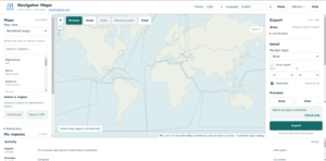
The standalone Navigator Maps app is now available in Beta. You can now pre-download and process offline maps directly to your USB-supported devices, eliminating the need to re-download map data before every journey.
Download regional maps, explore them offline and export map tiles to a folder, ZIP archive or USB drive. Capture tiles and share your maps over your local network.
Install SmartMyBoat Navigator for Roku and open Settings (option key) > Services > Download Navigator Maps for PC and enter email to yourself instruction on how to download the app.
Installation
Navigator Maps installs for your user account. A Start Menu shortcut is included, and you can choose to add a desktop shortcut.
Please close Navigator Maps before continuing with an update.
Your maps and settings
Your existing map library and preferences are retained. Updating or uninstalling Navigator Maps preserves your downloaded maps, captured tiles and exported files.
Captures from a portable copy are not transferred automatically.
Getting started
Open Navigator Maps from the Start Menu. Choose a region to download or open your existing library. The in-app Help guide explains map downloads, previews, exports, tile capture and local-network sharing.
How Navigator Maps Works
Regional OSM downloads contain raw map features (points, lines, and shapes) rather than static pre-rendered images or pre-set zoom levels. Downloading and importing data runs an initial processing step that prepares these features for fast on-device rendering later.
Water depth is sourced from a separate global dataset rather than OSM regional files.
Built-in Natural Earth Overview: The app includes a lightweight Natural Earth land, sea, and coastline dataset that is always accessible offline. It provides base previews and fills in coverage gaps where detailed regional data is missing. Note: This is vector/basemap data, not high-resolution aerial imagery.
Libraries vs. USB Exports
The Library stores your raw downloaded sources, prepared data, and reusable map tiles.
An Export Destination (e.g., your USB drive) receives a self-contained copy of these prepared files for use on external hardware.
The internal tile server streams data directly from your active local Library, not from exported USB folders.
Select an existing library or pick an empty folder to create a new one.
When merging multiple regional source extracts, all regional files must share matching snapshot dates/versions.
If the app detects conflicting source dates, it will throw an error rather than silently overwriting your data. To resolve this, use a matching regional source set or stick to a single region.
Exported tiles are saved on your target device using a standard Z/X/Y web-mercator tile structure.
Powered by regional OpenStreetMap extracts courtesy of Geofabrik.
Sourced from OpenDEM’s GEBCO 2021 polygon and contour dataset.
If you display these tiles in third-party software, you must retain the required legal attributions for OpenStreetMap, Geofabrik, Natural Earth, and OpenDEM/GEBCO.
Depth contours are for general background/overview purposes only and must not be used for precise navigational soundings or close-quarters marine navigation.
Nautical markers and navigation aids depend entirely on availability in the underlying OSM source data and the symbols supported by the rendering engine.
While Navigator Maps can host and serve pre-captured satellite or aerial imagery, the app cannot download or render aerial imagery directly.